


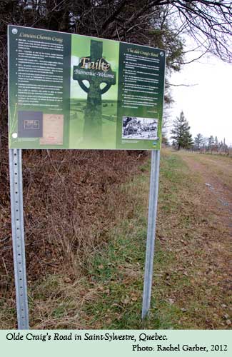
Olde Craig’s Road
Organization: Coirneal Cealteach
Address: Sainte-Agathe-de-Lotbinière, QC
Region: Chaudière-Appalaches
Contact: Steve Cameron, tirnanogsa(a)gmail.com
Description: A section of the Craig’s Road established in 1810 that was a stagecoach line connecting Quebec to Boston. This section is preserved in approximately its original state.
Year made: 1810
Made by: James Henry Craig (1748-1812)
Materials/Medium: Natural vegetation, gravel
Colours: Natural landscape
Provenance: Municipalité de Saint-Sylvestre, Quebec
Size: 200 m
Photos: Rachel Garber
The Craig's Road
Steve Cameron
The story of the Craig’s Road has frequently been oversimplified as a road that connected Quebec City to Boston with little further reflection as to its beginning, its role or its importance to the history of Quebec. It is a story can only be comprehended by viewing the road through the lens of its beginnings, and within the context of the time period in which it evolved and developed.
Following the Conquest of New France in 1760 and until the turn of the 19th century, there was little development in the area southwest of Quebec City including south of the St Lawrence River, west of the Chaudière River and east of the Richmond and Sherbrooke line. This empty zone acted as a buffer to the emergence of the independent United States to the south and was only inhabited by the Abenaki, who frequented its territory for hunting and fishing.
By the early 1790s, efforts to ‘at least’ survey the area were undertaken with the newly formed “Eastern Townships” as a result of the Constitutional Act of 1791. The resultant townships covered the area from the American border north towards the St. Lawrence River and east towards the already existing seigneuries of Ste. Croix, St. Giles and Lauzon. The eastern-most townships of Uxbridge, Leeds, Broughton, Inverness, and Ireland were established but remained empty of settlement.
By 1800, the population of Lower Canada was estimated to be approximately 220,000, with French-speaking citizens representing 80-90% of the population and living in the seigneuries along the St. Lawrence River and in the cities of Quebec, Trois Rivières and Montreal. The English-speaking population was in the minority but held positions of authority in commerce, trade and politics.
The arrival of James Henry Craig (1748-1812) in 1807 as Governor General of the Canadas and Lieutenant Governor of Lower Canada changed the dynamics of the colony. Born of Scottish parents in Gibraltar, Craig established a name and career for himself as a skilled military officer.
Along with the chief justice of Lower Canada, Jonathan Sewell (1766-1839), Craig was sensitive to the vulnerability of the English-speaking minority and intended to alter that fact. Despite opposition from the Lower House, controlled primarily by French-speaking representatives who feared being over-run by more English-speaking settlers, Craig and Sewell felt the need to develop the vast under populated area south of the St. Lawrence River. The establishment of a road through this region would encourage settlement from the United Empire Loyalists arriving from the newly formed United States, as well as immigrant English-speaking people from the British Isles. The idea of strengthening the English-speaking presence in the colony and even assimilating the majority French-speaking population was never far from their strategies.
By 1810, Craig took the matter into his own hands. Despite opposition from the Lower House, he decided to open up the fore-noted territory and build the road himself. He leveraged the existence of an earlier proposed road, a design completed by Joseph Kilborn in 1800 but never initiated, to speed up the eventual survey work by the Surveyor General of British North America, Joseph Bouchette (1774-1841). He also made use of British troops to construct the road. Kilborn’s design was modified by Bouchette to reflect the urgency of the project. Led by Quarter-Master General J. Kempt and a Major Robinson, a contingent of soldiers and the Army Corps of Engineers began the road in October 1810 and completed it approximately three months later in January 1811.
The road was to leave St Nicholas some 19 kilometres west of Quebec City on the south shore of the St. Lawrence River, and head towards St. Gilles along the western side of the Beaurivage River. It would then continue west of what is now St. Sylvestre, across the Filkars and Palmer Rivers and continue west through Uxbridge and Leeds, crossing the Sunday and Osgood Rivers. Heading along the Leeds and Inverness border and crossing Bullard’s Brook, the road continued by the south end of Trout Lake at the mouth of the Thames River (today the Bécancour River). The road then went through a corner of Halifax, on to Wolfestown and Tingwick and eventually to Shipton, Danville and Richmond. From here, the connection to Boston was complete, as there was already an established road from Richmond via Sherbrooke to Boston.
It was estimated that along the road, which was generally 4.57 metres wide, there were 120 bridges completed, 24 being over large streams, and that the distance covered was approximately 120 kilometres (St Gilles to Richmond). There was much anticipation about the opening of the road and the propaganda was ever present in government statements. The fanfare continued with the announcement of the first stage coach link between Quebec and Boston. A coach circuit was established by Josiah Stiles of Quebec City whereby one could cover the distance in six days along the newly opened road. It was soon dubbed the "Craig’s Road."
By the spring of 1811, nature’s reality confronted the stage coach operation with the spring thaw. Combined with the severe hills of the portion from St. Sylvestre and Leeds to the Trout Lake, and the low-lying regions which flooded the corduroy sections of the road, the stage coach quickly became dysfunctional. In addition, no infrastructure such as inns of note existed, and when they did, they were of questionable repute and quality.
Another situation that threatened the success of the road was the commencement of the War of 1812. If the road could be used to link Quebec to Boston in a north-south direction, there was a fear that it could also provide the US military with a south-north route. Allowing Mother Nature to retake the road was a simple way for it to become impassable. Added to this was the belief that a few Loyalists had destroyed some of the bridges that had been built only the year before. Even if this was only oral hearsay, no traveller would want to risk setting out on a road only to be turned back. It should be noted that there is no evidence that Americans ever used the Craig’s Road to come north although there is a persistent oral tradition that states that it was used by American spies. In fact, despite its promise to provide greater opportunities for land and settlement and improved access to markets, the road was in most parts not much more than a pathway. Governor Craig himself was accused of neglecting his road and by 1814, surveyor Joseph Bouchette considered it impractical and almost wilderness again.
In 1815, Bouchette again assessed the seigneury of St. Gilles as having only 10,000 acres of cleared land, with over 150,000 acres still forested and very little settlement. The year 1815 also saw the defeat of Napoleon. This seminal event in Europe led to waves of immigrants from the British Isles during 1815-1835 because of a general decline in Great Britain’s economy. After a slow trickle, many Scottish and Irish settlers, both Roman Catholic and Protestant, started to flood the townships in the mid to late 1820s. Their numbers further intensified in the early 1830s, partially as a result of the presence of cholera in Quebec City and Montreal. The chief immigration officer for the Canadas at the time was A.C. Buchanan. He encouraged settlement in the Eastern Townships and diverted many of the newcomers to travel the Craig’s Road where land was plentiful and a critical mass of population was establishing itself.
By mid century, the French-speaking population was growing, and needed land. They began migrating off the seigneuries along the St Lawrence and moving west from the Beauce. In fact, between 1815 and 1850, the number of towns and villages in Quebec increased from 50 to 300. Movement along the Craig’s Road was never ideal. Its physical attributes, including its hills and rivers, were always a challenge. As the population growth continued beyond the Leeds and Inverness territory, a need for a quicker, less challenging route was sought. By the early 1830s, a winter road leaving the Craig’s Road just south of St. Gilles towards Inverness (via Nelson Township) bypassed the worst of the hills around St. Sylvestre and Leeds. This new road went through Inverness and north of Lake Joseph and Lake William and reconnected to the Craig’s Road west of what is now St. Ferdinand de Halifax.
By the 1840s, this effort eventually became a permanent road known as the Gosford Road. Combined, the Craig Road and the Gosford became lifelines to the territory. The Craig Road was the mainstream route for the eventual settlement and commercial activity for much of the eastern portion of the Eastern Townships. While the territory developed, and its Irish, Scottish and Loyalist population all played a significant role, the French-speaking population was never assimilated. In fact, over the long term, they thrived and quickly became the majority in the area. In the end, Governor Craig’s vision was only partially achieved; settlement and development of the region was realized but assimilation of the French-speaking population into the English-speaking population was not accomplished.
Today many local citizens frequently refer to Route 269 as the Craig’s Road and while this is only partially true, a few signs can still be seen brandishing the name. Over the years, the original track of the road has been altered, widened, straightened, re-routed, paved over, and literally “put to pasture” and almost forgotten. Fortunately, one specific length of the road approximately 200 metres long has hardly been touched at all. It lies in the Municipalité de St. Sylvestre. In 2012, under the guidance and at the initiative of “Coirneal Cealteach” an Irish Heritage group, and with the cooperation of the St. Sylvestre municipality, this 200 metre stretch of the “Olde Craig’s Road” was declared an historic site. It remains approximately 5.4 metres in width, is unpaved, has no ditches, and is as close as it can be to its original condition. For all of those whose ancestors settled this area prior to 1840, it is a certainty that they actually passed on this specific piece of road.
The simplicity of this specific site underestimates its importance at the time of settlement. When visiting the site, we are immediately reminded of our ancestors and their presence in this region, as an early cemetery dating from the late 1840s known as the St. Sylvestre West Anglican and Presbyterian Graveyard sits close to the road, reminding us of their presence still.
Sources
Joseph Bouchette and William Faden, “1815 Map of Lower Canada: To His Royal Highness George Augustus Frederick…This Topograpgical map of the Province of Lower Canada, shewing its division into Districts, Counties, Seigniories & Townships…Joseph Bouchette, His Majesty’s Surveyor General…Published by W. Faden, Charing Cross, London, August 12th 1815.”
Joseph Bouchette, “1832 Map of The Districts of Quebec, Three Rivers, Lower Canada: To his most Excellent Majesty, King William IV, this Topographical Map of the District of Montreal, Lower Canada, Exhibiting the New Civil Division of the District into Counties pursuant to a recent act of the provincial legislature…Joseph Bouchette, His Majesty’s Surveyor General of the province…Published by James Wyld, Charing Cross, London, May 2nd 1831.
Joseph Kilborn, “Plan for Outline of Leeds Township,” 1801.
Jean-Baptiste Duberger and Samuel Gale, “Plan of part of the Province of Lower Canada containing the country from the River Montmorency near Quebec upwards as far as any survey have been hitherto made that is to St. Regis on the River St. Lawrence and to the Township of Buckingham on the River Ottawa ...': map (of territory now in Quebec province, Canada). Reference tables to boundaries and encroachments; reference notes on sources. Scale: 1 inch to 4 miles. Produced by order of Lord Dorchester, Governor in Chief of Upper and Lower Canada; compiled at the Surveyor General's Office by Samuel Gale and John B. Duberger, 1794-1795.”
1873 Map of St Sylvestre.
“Quebec Mercury,” November 1810-April 1811.
“Patent for Township of Leeds,” 1801-1802.
“Petition for Uxbridge,” 1792.
B. L’Ecuyer, Surveyor Field Book for Canton Leeds, 1811.
Joseph Bouchette, “A topographical dictionary of the province of Lower Canada,” 1832. www.archive.org
Gwen Rawlings Barry, ˝La piste Bécancour : des campements abénaquis dans l’arrière-pays,Recherches amérindiennes au Québec,˝vol. 33, no 2, 2003.
Gwen Rawlings Barry, A History of Megantic County: Downhomers of Quebec’s Eastern Townships, 1999.
To Learn More
Uxbridge was a far eastern township established in 1792 that eventually disappeared through a merger and the finalization of the border between the Townships and the Seigneuries of the time. For more information about the Uxbridge story, please contact the writer.
The Craig Road, www.richmondcountyhistoricalsociety.com
Megantic County Heritage Trail, www.quebecheritageweb.com
1834 Emigrants Handbook – Arrivals at Quebec, www.jubilation.uwaterloo.ca
1806--Population of Lower Canada estimated at 250,000. Bouchette, The British Dominions, Vol. II., page 235, www.statcan.gc.ca
The Craig’s Road in St. Sylvestre, www.cbc.ca/breakaway
Heather Darch, “The Emerging Road: Building a Lifeline Across the Townships,” http://www.letoursutton.com/244/darch_emrg_roads_244.htm
Author
Steve Cameron is a writer and the co-founder of the Irish historical and heritage group Coirneal Cealteach
